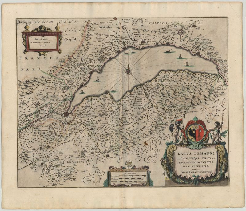
2450 Janssonius, Johannes: Lacus Lemanni Locorumque Circumiacentium Accuratissima Desriptio 1656

vendor-unknownSKU: 2450
Keine Bewertungen

Preis:
Sonderpreis$1,008.00

inkl. MwSt. Versandkosten werden im Checkout berechnet.

Lagerbestand:
Auf Lager

Beschreibung

Alpine region / Switzerland / Lake Geneva
Alpenländer / Schweiz / Genfer See
Janssonius, Johann
1656

English
Switzerland / Lake Geneva

Janssonius, Johann
1656
copperplate engraving
51,5 x 41 cm
ORIGINAL

A very nice crisp and detailed map from Switzerland with three decorative cartouches and an ornate font. The cartouche label is in Latin with French place names. There are a number of fortified cities and towns. Jacques Goulart (1580-1622) was a Swiss theologian and cartographer. This is a northerly orientated map. Janssonius maps is a later edition of the same area with elaborate cartouches and a compass rose added in the middle of the lake. Johannes Janssonius (1588-1664) was the son of a bookseller and publisher from Arnhem. In 1612 he married the daughter of the cartographer Jodocus Hondius and opened his own shop in Amsterdam. In 1616 he published his first maps of Italy and France. In 1638 he contributed to a complete revision of the Atlas made by Mercator-Hondius the Nouvel Atlas which was published in two volumes. Janssonius has based this map of a ealier version of the region by Joan Blaeu.

Tooley's Dictionary of Mapmakers, Early World Press 2004, p429


Deutsch
Schweiz / Genfer See

Janssonius, Johann
1656
Kupferstich
51,5 x 41 cm
ORIGINALKARTE

Sehr schöne Karte von der Schweiz mit drei dekorativen Kartuschen und schmuckvollem Schrifttyp. Die gesamte Karte ist detailliert gestochen. Die Kartuschenbeschriftung ist lateinisch, die Ortsbezeichnungen französisch. Es zeigen sich eine Vielzahl von befestigten Städten und Orten bis hin zu einzelnen Landhäusern.Vorlage für die Ansicht war die „Tabula Lacus Lemanni“ des Schweizer Theologen und Kartographen Jacques Goulart (1580-1622). Genordet ist die Karte jedoch erst seit der Adaption von Jean-Babitste Vrient aus dem Jahre 1608, die in Ortelius „Theatrum“ erscheint. Janssonius Karte ist ein Neustich des gleichen Gebietes mit aufwendigen Kartuschen und einer zusätzlichen Kompassrose in der Mitte des Sees.


Das könnte Sie auch interessieren

Zuletzt angesehen