

Beschreibung
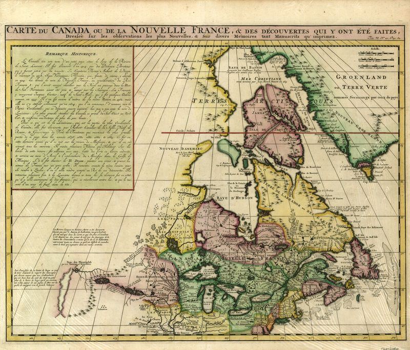
Carte du Canada ou de la Nouvelle France
Henri Abraham Châtelain
Eine wichtige Karte für die Geschichte Kanadas aus dem "Atlas Historique". Sie basiert auf de L'Isles berühmter Karte von Kanada aus dem Jahr 1703 und ist für ihre Zeit sehr genau. Ein Kasten oben links enthält einen französischen Text, der die Geschichte des Gebiets von Jacques Cartier bis zur Veröffentlichung beschreibt. Rund um Hudons Bucht und Labrador sind die Eingeborenen als "Christinaux", "Kilistinons" und "Eskimaux" aufgeführt. An der Küste stehen die Namen der Entdecker und die Daten ihrer Entdeckungen. Ein häufiger kartografischer Fehler ist die "Riviere Longue", ein imaginärer Fluss, der vom "Pays des Gnacsitares" zum Pazifik fließen sollte. Dieser stammt aus dem meistverkauften Reisebuch des französischen Abenteurers "Nouveaux voyages dans l'Amerique septentrionale". Henri Abraham Chatelain (1684-1743) war der Sohn von Zacharie Chatelain. Seine bekannteste Veröffentlichung war der siebenbändige "Atlas Historique", der in Amsterdam erschien.
handkolorierter Kupferstich
Bildmaß: 41,5 x 53 cm (Höhe x Breite)