

Beschreibung
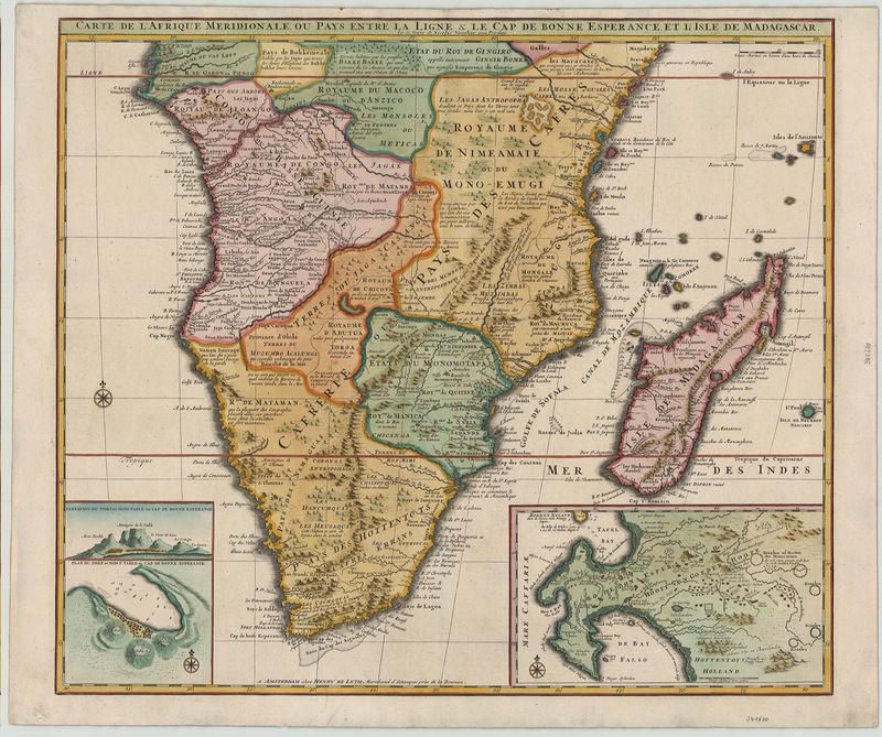
Carte de l` Afrique Meridionale ou Pays entre la Ligne & le Cap de Bonne Esperance et l` Isle de Madagascar
Hendrik de Leth
Sehr genaue, kolorierte Karte vom südlichen Teil des afrikanischen Kontinents. Unten rechts große Nebenkarte des Kap-Distriktes, von beachtlichem historischem Wert, da sie die verschiedenen niederländischen Ansiedlungen mit Namen der Eigentümer angibt. Unten links kleinere Nebenkarte mit Hafen, Tafelberg und Silhouette der Küstenlinie.
handkolorierter Kupferstich
Bildmaß: 50,5 x 58 cm (Höhe x Breite)
This is a detailed map of the southern half of the African continent. At the bottom right is a map of the Cape district and it serves as an important historical source as it indicates the various Dutch settlements with the names of its owners at that point in history. The bottom left has a smaller map with a harbor, Table Mountain and its famous skyline near Cape Town. Henry de Leth the Elder (c. 1703-1766) was an engraver, publisher and artist based in Amsterdam. His atlas of the Netherlands, the 'Nieuwe en Geographical Historical Atlas van de Zeven Vereengde Nederland "was very successful. This was first published in 1740 in the later in several more issues.
handcolored copperplate engraving
Size: 50,5 x 58 cm (Height x Width)