

Beschreibung
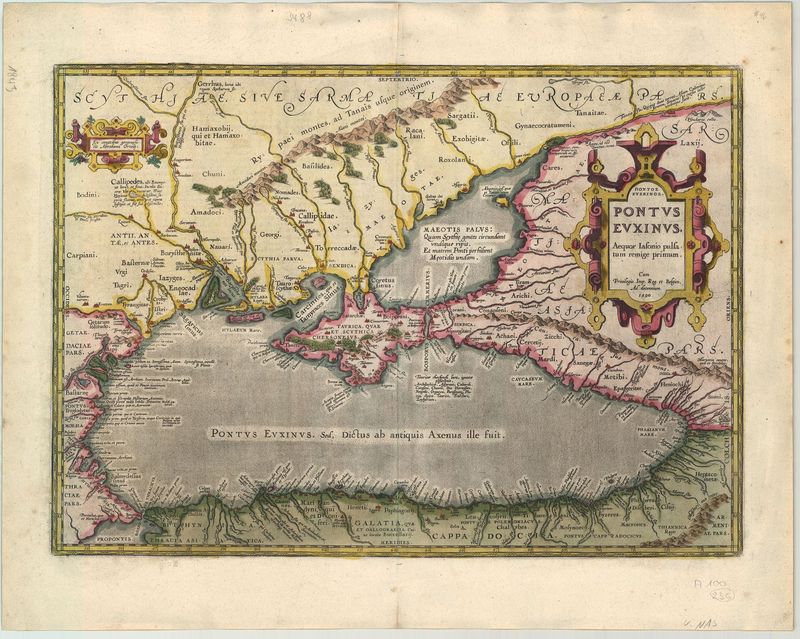
Pontus Euxinus. Aequor Iasonis pulsatum remige Primum
Abraham Ortelius
Diese faszinierend detaillierte Karte des Schwarzen Meeres geht zurück auf den berühmten Antwerpener Gelehrten Abraham Ortelius (1527–1598). Ursprünglich war das Blatt Teil des Atlasses „Theatrum Orbis Terrarum“. Während der Atlas zum ersten Mal im Jahr 1570 erschien, ist die Darstellung des Schwarzen Meeres ab dem Jahr 1590 gedruckt worden – sie war Teil des ergänzenden Geschichtsatlasses „Parergon“, dem ersten historischen Kartenwerk überhaupt.
Das Kartenbild zeigt nicht nur das Schwarze Meer mit der Krim im Bildzentrum, sondern auch das heute so genannte „Asowsche Meer“. Faszinierend ist die Detailgenauigkeit, mit der Ortelius die Hafenstädte entlang der Küsten und die tief ins Landesinnere führenden Flüsse darstellt. Auffällig ist wiederum, dass die dabei gewählten Namen auf die antike Geschichte rekurrieren – ebenso wie der Titel der Karte, in dem Jason genannt wird, der mit den Argonauten das „Goldene Vlies“ raubte, um es vom Schwarzen Meer nach Thessalien zu bringen.
Das Schwarze Meer galt aufgrund seiner stürmischen Wundverhältnisse lange Zeit als äußerst „unfreundlich“. So schrieb zum Beispiel der römische Dichter Ovid: „Mich halten die kalten Gestade des Pontus Euxinus, der bei den Alten der Unwirthbare (axeinos) hieß. Denn hier wird das Meer nicht von mäßigen Winden beweget, und kein fremdes Schiff besuchet einen ruhigen Hafen. Völker sind umher, die Beute durch Blut suchen, und das Land wird nicht minder gefürchtet, als das treulose Wasser“. Ortelius rekurriert mit dem Titel seiner Karte auf diese Legendenbildung.
altkolorierter Kupferstich
Bildmaß: 35,5 x 50 cm (Höhe x Breite)