

Beschreibung
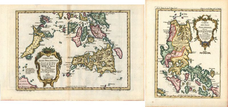
Carte des isles Philippines, 1re et 2e Feuille
Jacques Nicolas Bellin
Diese beiden wundervoll kolorierten Karten der Philippinen gehen zurück auf den berühmten französischen Kartografen Jacques Nicolas Bellin (1703–1772). Ursprünglich waren die Blätter Teil des kleinformatigen Seeatlasses „Le Petit Atlas Maritime Recueti de Cartes et Plans des Quatre Parlies du Monde en Cinq Volumes“ (Paris, 1764). Danach wurden die Karten aber zudem noch einmal abgedruckt in einem bedeutenden Reisebericht des französischen Autors Antoine François Prévost („Histoire General des Voyages, ou nouvelle collection de toutes les relationes de voyages par mer et par terres“, Paris, 1746–1753).
Da Bellin auf die Anfertigung von Seekarten spezialisiert war, besitzen die beiden Karten eine wundervolle Detailgenauigkeit. Darüber hinaus verleiht ihnen die schöne Kolorierung eine ungemein dekorative Wirkung. Für seinen Entwurf stützte sich Bellin auf eine ältere Darstellung des Kartografen Murillo de Velarde (1696–1735), einem Jesuiten, der in Manila als Missionar wirkte . 1734 entstand die erste wissenschaftliche Karte der Philippinen durch Francisco Suarez, die de Velarde 1752 in einem Buch veröffentlichte.
handkolorierter Kupferstich
Bildmaße: 15,6 x 21 bzw. 30,1 x 20,9 cm (Höhe x Breite)