

Beschreibung
Hunc Borysthenis tractum
Willem Janszoon Blaeu
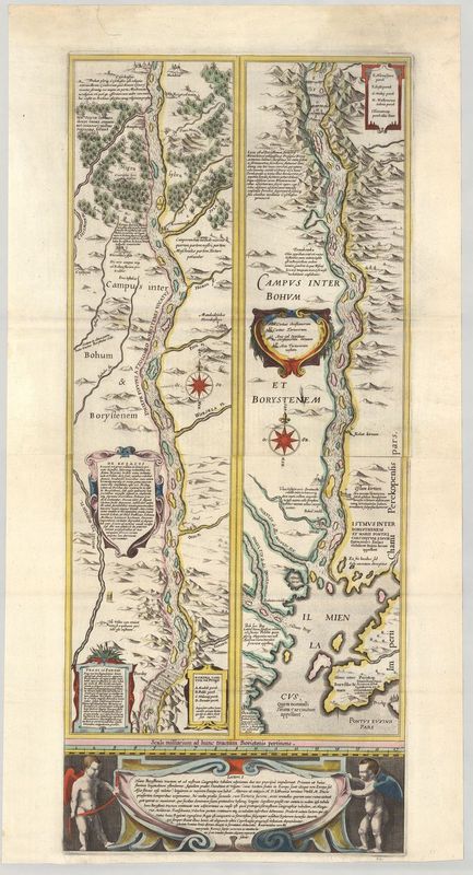
Diese faszinierende des osteuropäischen Flusses Dnepr geht zurück auf die berühmten Amsterdamer Verleger Willem Janszoon Blaeu (1571–1638). Es handelt sich um die erste großformatige Karte des Dnepr überhaupt! Die Darstellung wurde zunächst separat gedruckt und war ab 1630 auch Teil von Atlanten des Verlags Blaeu.
Das Kartenbild ist in zwei vertikale Register geteilt, um den Dnepr in Gänze abbilden zu können. Das Kartenbild reicht von der ukrainischen Stadt Tscherkassy bis zum Schwarzen Meer. Faszinierend ist die Genauigkeit der Zeichnung, denn sie zeigt auch die zahlreichen Flussinseln und Ortschaften entlang des majestätischen Stroms. Der lateinische Begleittext schildert die Geschichte der Region, die kleinen Kommentare im Kartenbild bezeichnen unter anderem Gebäude, Minen und Befestigungsanlagen.
Die Karte hat eine interessante Veröffentlichungsgeschichte, denn als Vorlagediente eine riesige Wandkarte von Litauen, die aus sechs Blättern zusammengesetzt war („Magni Ducatus Lithuaniae“). Ihr Autor war der Adlige Mikolaj Krysztof Radziwill-Makowski. Erschienen ist die Wandkarte ebenfalls im Amsterdamer Verlag Blaeu (1613–c. 1655). Teilweise erschien die Karte auch als Faltblatt in Atlanten der Offizin.
handkolorierter Kupferstich
Bildmaß: 75,6 x 32,6 cm (Höhe x Breite)