

Beschreibung
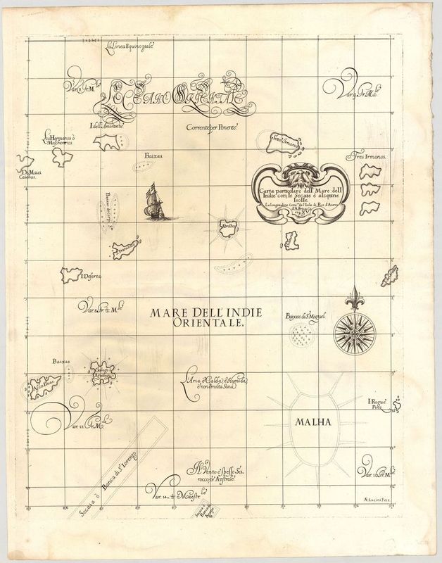
Carta particolare dell Mare dell Indie con le Secaie è alcqune Isolle
Robert Dudley
Diese außergewöhnliche Seekarte der Seychellen und des Indischen Ozeans stammt von dem bekannten britischen Schiffsoffizier und Entdecker Sir Robert Dudley (1574–1649). Entstanden ist das Blatt in der Zeit um 1646; es war Teil des Atlasses "Dell'Arcano del Mare" – dem ersten Seeatlas, der die ganze Welt umfasste!
Das Kartenbild zeigt die Seychellen und Madagaskar in einer einzigartigen Gestaltung: Die Inseln wirken wie kleine Organismen, die im Wasser schwimmen. Verantwortlich für die dekorativen Details der Darstellung, wie die wunderbaren Schiffe, die groteske Kartusche oder die kalligrafischen Schriftzüge, war ein bekannter florentinischer Kupferstecher, Anton Francesco Lucini (1610–ca. 1661). Die von ihm entworfenen Details verstärken noch einmal die Einzigartigkeit von Dudleys Karten.
unkolorierter Kupferstich
Bildmaß: 47,6 x 38 cm (Höhe x Breite)