

Beschreibung
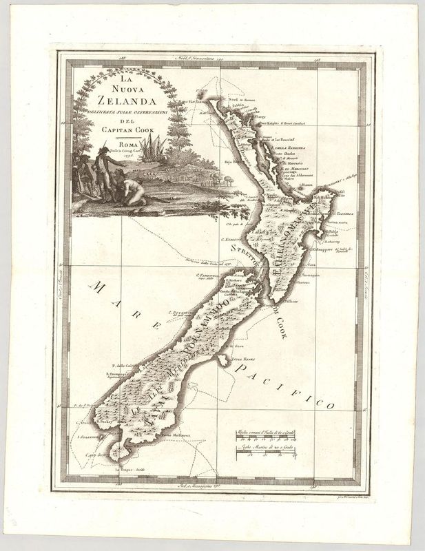
La Nuova Zelanda
Giovanni Maria Cassini
Diese sehr seltene Karte von Neuseeland geht zurück auf den italienischen Verleger Giovanni Maria Cassini (1745–ca. 1824). Ursprünglich war das Blatt Teil des „Nuovo Atlante Geografico Universale“ (Band 3, Tafel 35). Die Karte zählt zu den gesuchtesten Darstellungen von Neuseeland überhaupt.
Cassini stützte sich für seinen Entwurf auf eine Karte, die in der italienischen Ausgabe des offiziellen Expeditionsberichts von James Cook über seine erste Südseereise (1768–1771) abgedruckt war. Deshalb ist auch die Reiseroute Cooks auf dem Kartenbild zu erkennen. Cooks Schiff „Endeavor“ ist wiederum im Hintergrund der Kartusche zu erkennen.
Kartografisch interessant ist, dass die heute so genannte „Stewart Island“ (Rakiura) noch als Halbinsel dargestellt ist, während die „Banks-Halbinsel“ an der Ostküste der Südinsel als eigenständiges Eiland gezeichnet ist.
unkolorierter Kupferstich
Bildmaß: 47,7 x 34,8 cm (Höhe x Breite)