

Beschreibung
Totius Europae Littora Novissimè edita. Pascaert vertoonende alle de See-custen van Europa
Louis Renard
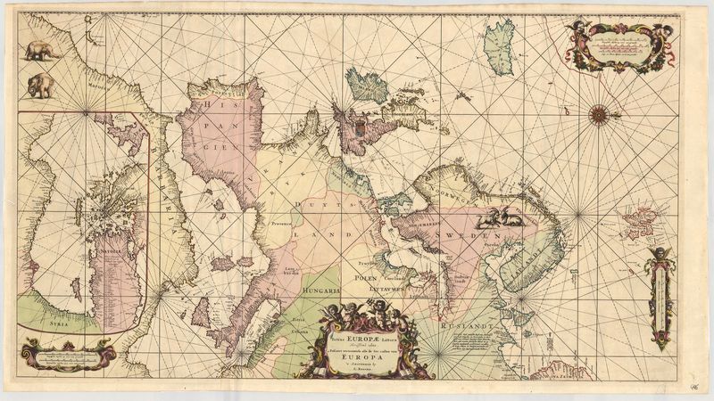
Diese majestätische Seekarte der europäischen Küsten geht zurück auf den berühmten französischen Verleger Louis Renard (1678–1746). Ursprünglich war die Karte Teil des „Atlas de la Navigation, et du Commerce“. Es handelte sich um die dritte Karte des Atlasses und das Blatt war ursprünglich zum Ausfalten gedacht.
Das Kartenbild ist nach Westen orientiert und in zwei Teile geteilt. Das Gros der Darstellung zeigt das Mittelmeer bis zur Adria, den nördlichen Atlantik bis Island und Skandinavien. Da es sich um eine Seekarte handelt, sind zwar die Küstenlinien dicht beschriftet, das Landesinnere ist jedoch weitgehend unkartiert. Zu erkennen sind die Namen der abgebildeten Länder sowie einige wenige Tierpaare und Wappen. Im Bereich des Maghreb versteckt sich wiederum eine weitere Karte, die sich allerdings erst auf den zweiten Blick hin offenbart: Sie zeigt das östliche Mittelmeer bis nach Syrien. Das abstrakte Linienetz der sogenannten „Rumben“ diente der Navigation, deren Instrumente neben der Titelkartusche abgebildet sind.
Dank ihrer zunächst ungewohnten Darstellungsweise besitzt das wundervoll kolorierte Blatt eine faszinierende Strahlkraft: Es entfremdet den gewohnten Blick und fordert dazu auf, die Welt einmal neu zu betrachten.
altkolorierter Kupferstich
Bildmaß: 49,4 x 88,8 cm (Höhe x Breite)